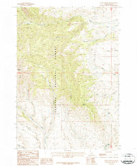
1987 Map of Heart Mountain
USGS Topo · Published 1987About this map
Targhee National Forest dominates this high-altitude landscape in Clark County, where the 1987 survey reveals a terrain defined by steep drainage networks and early mineral exploration. The presence of multiple prospects along the western slopes of Heart Mountain and near Myers Creek indicates historical prospecting activity, likely tied to the region's mining heritage. These sites are scattered across the headwaters of Webber Creek and Mc Neary Creek, providing specific coordinates for researchers investigating old claims.
Find a feature on this map
20 named features on this map. Tap any name to fly to it.
Don’t see what you’re looking for? This feature index may not catch every label — zoom into the map to look around manually.
Map Details
Editions of this 1987 Heart Mountain Map
This is the sole edition of this map. No revisions or reprints were ever made.
Other maps of this area

1955 · Dubois
USGS Topo · 1:250,000

1957 · Scott Peak
USGS Topo · 1:62,500

1957 · Edie Ranch
USGS Topo · 1:62,500

1958 · Dubois
USGS Topo · 1:250,000

1969 · Shamrock Gulch
USGS Topo · 1:24,000

1969 · Copper Mtn
USGS Topo · 1:24,000

1969 · Lidy Hot Springs
USGS Topo · 1:24,000

1983 · Dubois
USGS Topo · 1:100,000
1987 · Deadman Lake
USGS Topo · 1:24,000
1987 · Fritz Peak
USGS Topo · 1:24,000