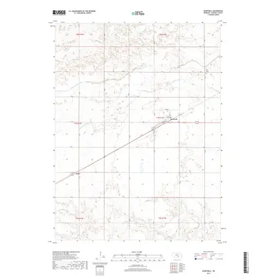
2017 Map of Heartwell
USGS Topo · Published 2017About this map
Heartwell serves as the primary hub of this Kearney County landscape, situated along a grid of section roads that define the agricultural character of the Nebraska plains. The settlement patterns follow the intersection of local routes like Main St and N Railway St, while the small community of Koller sits to the southwest. This area illustrates the critical role of water management in the region, featuring the Adams County Canal and natural drainage systems like Cottonwood Cr and Sand Cr. For family historians, the map identifies local burial grounds including Eaton Cem and Holy Family Cem, which are key landmarks for tracing the area's rural heritage. The infrastructure, consisting of a precise network from T Rd down to N Rd, reflects the organized expansion of farming and transportation across the central Nebraska territory.
Find a feature on this map
31 named features on this map. Tap any name to fly to it.
Don’t see what you’re looking for? This feature index may not catch every label — zoom into the map to look around manually.
Map Details
Editions of this 2017 Heartwell Map
This is the sole edition of this map. No revisions or reprints were ever made.
Other maps of this area

1894 · Kenesaw
USGS Topo · 1:62,500

1894 · Minden
USGS Topo · 1:62,500

1896 · Wood River
USGS Topo · 1:125,000

1897 · Red Cloud
USGS Topo · 1:125,000

1955 · Grand Island
USGS Topo · 1:250,000

1957 · Grand Island
USGS Topo · 1:250,000

1958 · Grand Island
USGS Topo · 1:250,000

1962 · Denman
USGS Topo · 1:24,000

1962 · Newark
USGS Topo · 1:24,000
1962 · Gibbon South
USGS Topo · 1:24,000