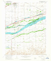
1962 Map of Gibbon South
USGS Topo · Published 1964About this map
The braided channels of the Platte River dominate this 1962 survey of the Nebraska plains, creating a complex geography of large landmasses like Clark Island and Elm Island. To the north, the town of Gibbon is situated along the Union Pacific railroad and the Wood River, while the southern reaches of the map show the settlement of Lowell positioned near the Chicago Burlington and Quincy tracks. The landscape is marked by the historical footprint of the Fort Kearney Military Reservation Bdy and the Old Fort Kearney road. Local civic life is evidenced by St Paul Ch, its nearby St Paul Cem, and rural educational outposts such as School No 22. The map also captures early interstate development with the inclusion of Interstate 80, illustrating the transition of Nebraska's primary transport corridors from rail and river to modern highway systems.
Find a feature on this map
30 named features on this map. Tap any name to fly to it.
Don’t see what you’re looking for? This feature index may not catch every label — zoom into the map to look around manually.
Map Details
Editions of this 1962 Gibbon South Map
3 editions found
Other maps of this area

1894 · Kenesaw
USGS Topo · 1:62,500

1894 · Minden
USGS Topo · 1:62,500

1895 · Wood River
USGS Topo · 1:62,500

1896 · Wood River
USGS Topo · 1:125,000

1955 · Grand Island
USGS Topo · 1:250,000

1957 · Grand Island
USGS Topo · 1:250,000

1958 · Grand Island
USGS Topo · 1:250,000

1962 · Denman
USGS Topo · 1:24,000

1962 · Newark
USGS Topo · 1:24,000
1962 · Gibbon North
USGS Topo · 1:24,000
Featured Places
- Gibbon, NE
- Lowell, NE
- L and J Mobile Home Court, Gibbon
- Sun Valley Trailer Court, Gibbon
- Buffalo County, NE