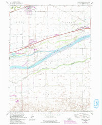
1962 Map of Gibbon South
USGS Topo · Published 1993About this map
Platte River braided channels dominate this Nebraska landscape, creating a series of substantial landforms including Fort Kearney Farm Island and Clark Island. The map documents a critical transportation corridor where the Union Pacific and Burlington Northern railroads parallel the river, serving the established settlements of Gibbon and Lowell. Evidence of the region’s frontier history is preserved in the Old Fort Kearney Military Reservation Bdy and the Old Fort Kearney Road. Local community life is rooted in features like School No 42, St Paul Ch, and the adjacent St Paul Cem. The transition toward modern land use is visible in the establishment of the Windmill State Wildlife Management Area and the Bassway Strip State Wildlife Management Area along the riverbanks.
Find a feature on this map
28 named features on this map. Tap any name to fly to it.
Don’t see what you’re looking for? This feature index may not catch every label — zoom into the map to look around manually.
Map Details
Editions of this 1962 Gibbon South Map
3 editions found
Other maps of this area

1894 · Kenesaw
USGS Topo · 1:62,500

1894 · Minden
USGS Topo · 1:62,500

1895 · Wood River
USGS Topo · 1:62,500

1896 · Wood River
USGS Topo · 1:125,000

1955 · Grand Island
USGS Topo · 1:250,000

1957 · Grand Island
USGS Topo · 1:250,000

1958 · Grand Island
USGS Topo · 1:250,000

1962 · Denman
USGS Topo · 1:24,000

1962 · Newark
USGS Topo · 1:24,000
1962 · Gibbon North
USGS Topo · 1:24,000
Featured Places
- Gibbon, NE
- Lowell, NE
- L and J Mobile Home Court, Gibbon
- Sun Valley Trailer Court, Gibbon
- Buffalo County, NE