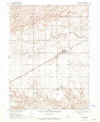
1969 Map of Heartwell
USGS Topo · Published 1971About this map
Heartwell centers this rural Nebraska landscape, where the Burlington Northern railroad cuts a diagonal line across a grid of section lines and irrigation wells. The map reveals a transition in land use and infrastructure, notably featuring the Adams County Canal (Abandoned) and an extensive network of field lines and local roads. On the western edge, the Fort Kearney Military Reservation Boundary serves as a historical marker of earlier frontier presence, contrasting with the mid-century agricultural development.
Find a feature on this map
20 named features on this map. Tap any name to fly to it.
Don’t see what you’re looking for? This feature index may not catch every label — zoom into the map to look around manually.
Map Details
Editions of this 1969 Heartwell Map
This is the sole edition of this map. No revisions or reprints were ever made.
Other maps of this area

1894 · Kenesaw
USGS Topo · 1:62,500

1894 · Minden
USGS Topo · 1:62,500

1896 · Wood River
USGS Topo · 1:125,000

1897 · Red Cloud
USGS Topo · 1:125,000

1955 · Grand Island
USGS Topo · 1:250,000

1957 · Grand Island
USGS Topo · 1:250,000

1958 · Grand Island
USGS Topo · 1:250,000

1962 · Denman
USGS Topo · 1:24,000

1962 · Newark
USGS Topo · 1:24,000
1962 · Gibbon South
USGS Topo · 1:24,000