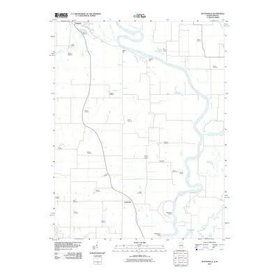
2010 Map of Heathsville
USGS Topo · Published 2010About this map
The Wabash River forms a wide, serpentine boundary through this Illinois-Indiana borderland, defining the geography of eastern Crawford County. The settlement of Heathsville sits centrally among a high concentration of rural burial grounds, including the Baker Cemetery, Fuller Cemetery, and Ganies Cemetery, which offer significant value for genealogical research in this river valley. To the north, the town of Palestine is situated near Lamotte Creek and a notable Indian Mound, signaling a landscape with deep historical layers.
Find a feature on this map
39 named features on this map. Tap any name to fly to it.
Don’t see what you’re looking for? This feature index may not catch every label — zoom into the map to look around manually.
Map Details
Editions of this 2010 Heathsville Map
This is the sole edition of this map. No revisions or reprints were ever made.
Other maps of this area

1917 · Birds
USGS Topo · 1:62,500

1942 · Birds
USGS Topo · 1:62,500

1943 · Merom
USGS Topo · 1:24,000

1943 · Carlisle
USGS Topo · 1:24,000

1943 · Oaktown
USGS Topo · 1:24,000

1943 · Sullivan
USGS Topo · 1:24,000

1953 · Indianapolis
USGS Topo · 1:250,000

1956 · Indianapolis
USGS Topo · 1:250,000
1956 · Sullivan
USGS Topo · 1:24,000

1956 · Vincennes
USGS Topo · 1:250,000