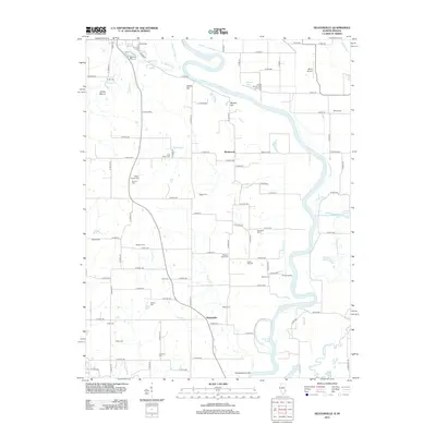
2012 Map of Heathsville
USGS Topo · Published 2012About this map
The Wabash River meanders across this landscape on the Illinois-Indiana border, carving out significant water features like the Horseshoe Cutoff and Johnsons Cutoff. This riverine environment is defined by its complex drainage, where No Business Cr and Sugar Cr feed into the main channel near Shaws Landing. The presence of an Indian Mound near Bristol Hill suggests a long history of human activity in the bottomlands long before the establishment of modern settlements like Heathsville and Richwoods.
Find a feature on this map
98 named features on this map. Tap any name to fly to it.
Don’t see what you’re looking for? This feature index may not catch every label — zoom into the map to look around manually.
Map Details
Editions of this 2012 Heathsville Map
This is the sole edition of this map. No revisions or reprints were ever made.
Other maps of this area

1917 · Birds
USGS Topo · 1:62,500

1942 · Birds
USGS Topo · 1:62,500

1943 · Merom
USGS Topo · 1:24,000

1943 · Carlisle
USGS Topo · 1:24,000

1943 · Oaktown
USGS Topo · 1:24,000

1943 · Sullivan
USGS Topo · 1:24,000

1953 · Indianapolis
USGS Topo · 1:250,000

1956 · Indianapolis
USGS Topo · 1:250,000
1956 · Sullivan
USGS Topo · 1:24,000

1956 · Vincennes
USGS Topo · 1:250,000