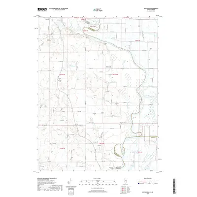
2018 Map of Heathsville
USGS Topo · Published 2018About this map
Heathsville sits at the heart of this Crawford County landscape, where the flatlands of the Wabash River valley meet the subtle rises of Shawn Hill and Bristol Hill. The map documents a deeply established rural community defined by a high density of family and community burial grounds, such as Wesley Chapel Cem, Bennett Cem, and Green Hill Cem, many of which represent generations of local agricultural heritage. Along the river, complex hydrological features like Johnsons Cutoff, Horseshoe Cutoff, and Minnow Slough illustrate the shifting nature of the state border between Illinois and Indiana. The presence of Indian Mound near the northern edge suggests ancient land use in the area, while the modern Mann Airport and numerous township roads indicate how the 21st-century infrastructure overlays this historic riverine and farming environment.
Find a feature on this map
142 named features on this map. Tap any name to fly to it.
Don’t see what you’re looking for? This feature index may not catch every label — zoom into the map to look around manually.
Map Details
Editions of this 2018 Heathsville Map
This is the sole edition of this map. No revisions or reprints were ever made.
Other maps of this area

1917 · Birds
USGS Topo · 1:62,500

1942 · Birds
USGS Topo · 1:62,500

1943 · Merom
USGS Topo · 1:24,000

1943 · Carlisle
USGS Topo · 1:24,000

1943 · Oaktown
USGS Topo · 1:24,000

1943 · Sullivan
USGS Topo · 1:24,000

1953 · Indianapolis
USGS Topo · 1:250,000

1956 · Indianapolis
USGS Topo · 1:250,000
1956 · Sullivan
USGS Topo · 1:24,000

1956 · Vincennes
USGS Topo · 1:250,000