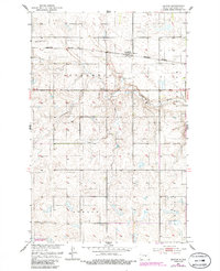
1951 Map of Heaton
USGS Topo · Published 1986About this map
Heaton stands as the primary rail-oriented settlement in this prairie landscape, situated along the Burlington Northern line. The town's local history is anchored by the Heaton Cem and a grid of rural schoolhouses, including School No 1 and School No 4, which served the surrounding agricultural townships of Speedwell, Berlin, and Sykeston.
Find a feature on this map
14 named features on this map. Tap any name to fly to it.
Don’t see what you’re looking for? This feature index may not catch every label — zoom into the map to look around manually.
Map Details
Editions of this 1951 Heaton Map
2 editions found
Other maps of this area

1948 · Cathay
USGS Topo · 1:62,500

1948 · Fessenden
USGS Topo · 1:62,500

1949 · Cathay
USGS Topo · 1:24,000

1949 · Fessenden SW
USGS Topo · 1:24,000

1949 · Emrick
USGS Topo · 1:24,000

1951 · Bowdon
USGS Topo · 1:24,000

1951 · Heaton
USGS Topo · 1:24,000

1951 · Sykeston
USGS Topo · 1:24,000

1952 · New Rockford
USGS Topo · 1:250,000

1956 · New Rockford
USGS Topo · 1:250,000