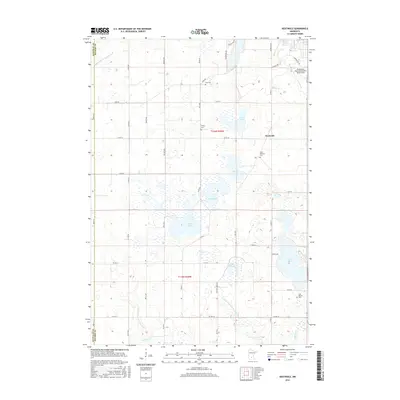
2016 Map of Heatwole
USGS Topo · Published 2016About this map
Glacial depressions and agricultural water management define this portion of the Minnesota prairie, situated along the border of Renville and McLeod counties. The landscape is dotted with prominent water bodies including Lake Marion, Eagle Lake, and Barber Lake, many of which are interconnected by an extensive network of man-made waterways like Judicial Ditch Number One and Judicial Ditch Number Four. These drainage systems illustrate the conversion of wetlands into productive farmland, a defining characteristic of the region's development.
Find a feature on this map
50 named features on this map. Tap any name to fly to it.
Don’t see what you’re looking for? This feature index may not catch every label — zoom into the map to look around manually.
Map Details
Editions of this 2016 Heatwole Map
This is the sole edition of this map. No revisions or reprints were ever made.
Other maps of this area

1953 · New Ulm
USGS Topo · 1:250,000

1957 · New Ulm
USGS Topo · 1:250,000

1958 · New Ulm
USGS Topo · 1:250,000

1958 · Winthrop
USGS Topo · 1:62,500

1958 · Hutchinson
USGS Topo · 1:62,500

1964 · Buffalo Lake
USGS Topo · 1:24,000

1967 · New Ulm
USGS Topo · 1:250,000
1967 · Cedar Mills
USGS Topo · 1:24,000
1967 · Lake Allie
USGS Topo · 1:24,000
1982 · Heatwole
USGS Topo · 1:24,000