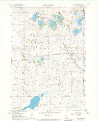
1967 Map of Cedar Mills
USGS Topo · Published 1968About this map
Cedar Mills and the surrounding prairie wetlands of Meeker County are defined by a complex network of glacial lakes and the winding South Fork Crow River in the late 1960s. This agricultural landscape is anchored by the Chicago and North Western railroad line, which passes through the village of Cedar Mills. The map documents a deeply established rural community, evidenced by the distribution of country schools and churches such as St Johns Sch, Spring Grove Ch, and Pipe Lake Sch. Substantial bodies of water like Boon Lake and Atkinson Lake dominate the southern and northern reaches, while the Greenleaf State Wildlife Management Area preserves the marshy terrain near Greenleaf. This survey provides a precise look at the township before modern land consolidation, marking numerous family-related sites and cemeteries including St Columban Ch Cem.
Find a feature on this map
30 named features on this map. Tap any name to fly to it.
Don’t see what you’re looking for? This feature index may not catch every label — zoom into the map to look around manually.
Map Details
Editions of this 1967 Cedar Mills Map
This is the sole edition of this map. No revisions or reprints were ever made.
Other maps of this area

1953 · New Ulm
USGS Topo · 1:250,000

1953 · Saint Cloud
USGS Topo · 1:250,000

1957 · Saint Cloud
USGS Topo · 1:250,000

1957 · New Ulm
USGS Topo · 1:250,000

1958 · New Ulm
USGS Topo · 1:250,000

1958 · Saint Cloud
USGS Topo · 1:250,000

1958 · Dassel
USGS Topo · 1:62,500

1958 · Hutchinson
USGS Topo · 1:62,500

1967 · New Ulm
USGS Topo · 1:250,000

1967 · Churchill
USGS Topo · 1:24,000