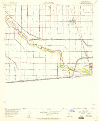
1957 Map of Heber
USGS Topo · Published 1958About this map
The agricultural landscape of the Imperial Valley is defined here by a massive irrigation network, as seen in the late 1950s. The New River snakes across the terrain, passing landmark locations like Lyons Crossing and a small Landing Strip on its northern bank. To the south, the city of Calexico sits directly on the international boundary, marked by the All American Canal and a Border Patrol Observation Tower. The intricate grid of the valley is sustained by a alphabetized series of water ways, including the Alder Canal, Dahlia Canal, and Lotus Canal. Further north, the town of Heber is a central hub for the region, while the Imperial County Hospital and Mountain View Cemetery serve the surrounding rural population. This map documents a period of intense water management and border-town development before significant modern expansion.
Find a feature on this map
37 named features on this map. Tap any name to fly to it.
Don’t see what you’re looking for? This feature index may not catch every label — zoom into the map to look around manually.
Map Details
Editions of this 1957 Heber Map
3 editions found
Other maps of this area

1907 · Holtville
USGS Topo · 1:125,000

1915 · El Centro
USGS Topo · 1:125,000

1940 · Brawley
USGS Topo · 1:62,500

1940 · Heber
USGS Topo · 1:62,500

1940 · Alamorio
USGS Topo · 1:62,500

1940 · Calexico
USGS Topo · 1:62,500

1942 · El Centro
USGS Topo · 1:250,000

1943 · Heber
USGS Topo · 1:62,500

1943 · Brawley
USGS Topo · 1:62,500

1943 · Calexico
USGS Topo · 1:62,500