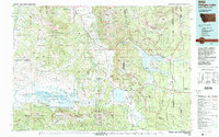
1993 Map of Hebgen Lake
USGS Topo · Published 1993About this map
The Madison Range and Gallatin Mountains converge in this high-altitude landscape where the borders of Montana, Idaho, and Wyoming meet. Centered on Hebgen Lake, the map documents the complex hydrology of the Madison River and the stark geological history represented by Earthquake Lake. The settlement of West Yellowstone serves as a gateway at the West Entrance to Yellowstone National Park, while further west, the Centennial Valley hosts the Red Rock Lakes National Wildlife Refuge. This region, largely comprised of the Beaverhead, Gallatin, and Targhee National Forests, includes specialized land uses such as the U S Sheep Experiment Station. Remote mountain peaks like Mount Jefferson and Sawtell Peak overlook a network of seasonal water bodies and the winding Rrlw rail line near the continental divide.
Find a feature on this map
91 named features on this map. Tap any name to fly to it.
Don’t see what you’re looking for? This feature index may not catch every label — zoom into the map to look around manually.
Map Details
Editions of this 1993 Hebgen Lake Map
2 editions found
Other maps of this area

1885 · Gallatin
USGS Topo · 1:125,000

1885 · Gallatin
USGS Topo · 1:125,000

1886 · Shoshone
USGS Topo · 1:125,000

1888 · Three Forks
USGS Topo · 1:250,000

1888 · Shoshone
USGS Topo · 1:125,000

1891 · Livingston
USGS Topo · 1:250,000

1893 · Dillon
USGS Topo · 1:250,000

1893 · Livingston
USGS Topo · 1:250,000

1894 · Three Forks
USGS Topo · 1:250,000

1895 · Three Forks
USGS Topo · 1:250,000