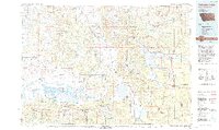
1993 Map of Hebgen Lake
USGS Topo · Published 1993About this map
West Yellowstone serves as the eastern gateway on this late-twentieth-century study of the high-country borderlands between Montana, Idaho, and Wyoming. The landscape is defined by massive water bodies and high peaks, notably Hebgen Lake with its Grayling Arm and Madison Arm. Nearby, Earthquake Lake marks the path of the Madison River, a reminder of the region's active seismic history. To the west, the Centennial Valley hosts the Red Rock Lakes National Wildlife Refuge, protecting the wetlands around Lower Red Rock Lake and the small settlement of Lakeview. This map effectively traces the convergence of several major federal lands, including the Gallatin National Forest, Targhee National Forest, and the edge of Yellowstone National Park, illustrating how recreation and conservation have shaped the local geography near the Yellowstone Airport.
Find a feature on this map
45 named features on this map. Tap any name to fly to it.
Don’t see what you’re looking for? This feature index may not catch every label — zoom into the map to look around manually.
Map Details
Editions of this 1993 Hebgen Lake Map
2 editions found
Other maps of this area

1885 · Gallatin
USGS Topo · 1:125,000

1885 · Gallatin
USGS Topo · 1:125,000

1886 · Shoshone
USGS Topo · 1:125,000

1888 · Three Forks
USGS Topo · 1:250,000

1888 · Shoshone
USGS Topo · 1:125,000

1891 · Livingston
USGS Topo · 1:250,000

1893 · Dillon
USGS Topo · 1:250,000

1893 · Livingston
USGS Topo · 1:250,000

1894 · Three Forks
USGS Topo · 1:250,000

1895 · Three Forks
USGS Topo · 1:250,000