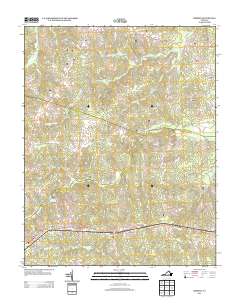
2013 Map of Hebron
USGS Topo · Published 2013About this map
Hebron and Ammon anchor this southern Virginia landscape, where small crossroads communities are linked by a network of rural routes like Richmond Rd and Cox Rd. The area is defined by its drainages, with the waters of Winticomack Cr, Namozine Creek, and White Oak Cr threading through the countryside. Evidence of local industry and water management appears at Hobbs Mill and the adjacent Hobbs Millpond north of the community of Wilsons. Many roads bear the names of local families and destinations, such as Gregory Mill Ln, Dews Farm Rd, and Old Richmond Rd, reflecting the deep-rooted agricultural and milling history of Amelia County. The terrain transitions from these watercourses to higher ground where settlements like Ammon sit at the intersection of several local connectors.
Find a feature on this map
49 named features on this map. Tap any name to fly to it.
Don’t see what you’re looking for? This feature index may not catch every label — zoom into the map to look around manually.
Map Details
Editions of this 2013 Hebron Map
This is the sole edition of this map. No revisions or reprints were ever made.
Other maps of this area

1897 · Amelia
USGS Topo · 1:125,000

1943 · Amelia
USGS Topo · 1:31,680

1943 · Goodes Bridge
USGS Topo · 1:31,680

1943 · De Witt
USGS Topo · 1:24,000

1943 · Church Road
USGS Topo · 1:24,000

1943 · Winterpock
USGS Topo · 1:24,000

1943 · Richmond
USGS Topo · 1:250,000
1944 · Winterpock
USGS Topo · 1:31,680
1944 · Church Road
USGS Topo · 1:31,680
1944 · DeWitt
USGS Topo · 1:31,680