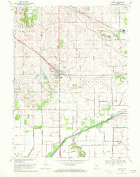
1969 Map of Hebron
USGS Topo · Published 1972About this map
Hebron serves as the primary hub of this landscape, situated at the intersection of a major Penn Central rail line and local thoroughfares. To the north, the small settlements of Hurlburt and Boone Grove are connected by a network of drainage infrastructure, including the Erie-Lackawanna and Cornell Ditch, which manage the low-lying terrain typical of this Indiana region. The southern edge of the map is defined by the broad path of the Kankakee River, which serves as the boundary between Porter Co and Jasper Co. This area reveals a transition from the structured street grid of town life to a more dispersed agricultural pattern. Genealogists and local historians can locate several important burial sites, such as the Hebron Cem and Cornell Cem, along with distinct water features like Dog Lake and Fisher Pond that shaped the early settlement and transport routes of the township.
Find a feature on this map
27 named features on this map. Tap any name to fly to it.
Don’t see what you’re looking for? This feature index may not catch every label — zoom into the map to look around manually.
Map Details
Editions of this 1969 Hebron Map
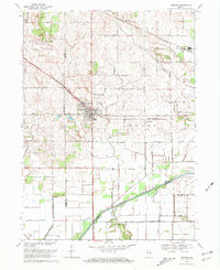
2 editions found
Other maps of this area

1953 · Leroy
USGS Topo · 1:24,000

1953 · Palmer
USGS Topo · 1:24,000

1953 · Crown Point
USGS Topo · 1:24,000

1953 · Hebron
USGS Topo · 1:24,000

1953 · Valparaiso
USGS Topo · 1:24,000

1953 · Kouts
USGS Topo · 1:24,000

1953 · Chicago
USGS Topo · 1:250,000

1957 · Chicago
USGS Topo · 1:250,000

1957 · Wheatfield
USGS Topo · 1:24,000

1957 · DeMotte
USGS Topo · 1:24,000