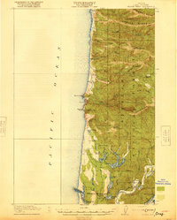
1920 Map of Heceta Head
USGS Topo · Published 1920About this map
Heceta Head L H and the adjacent Coast Guard Station anchor this coastal survey, which reveals the remote character of Lane County just after the First World War. The rugged Pacific coastline is defined by prominent landmarks like Sea Lion Point and Cape Mtn, while the interior is dominated by the heavily timbered lands of the Siuslaw National Forest.
Find a feature on this map
58 named features on this map. Tap any name to fly to it.
Don’t see what you’re looking for? This feature index may not catch every label — zoom into the map to look around manually.
Map Details
Editions of this 1920 Heceta Head Map
4 editions found
Other maps of this area

1918 · Mapleton
USGS Topo · 1:48,000

1919 · Earl
USGS Topo · 1:48,000

1920 · Siltcoos Lake
USGS Topo · 1:62,500

1920 · Heceta Head
USGS Topo · 1:62,500

1922 · Waldport
USGS Topo · 1:62,500

1940 · Mapleton
USGS Topo · 1:62,500

1941 · Siltcoos Lake
USGS Topo · 1:62,500

1942 · Waldport
USGS Topo · 1:62,500

1942 · Heceta Head
USGS Topo · 1:62,500

1942 · Siltcoos Lake
USGS Topo · 1:62,500