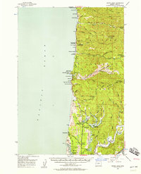
1956 Map of Heceta Head
USGS Topo · Published 1958About this map
Heceta Head Lighthouse stands as a prominent sentinel on the Lane County coast, marking a landscape where the Siuslaw National Forest meets the Pacific Ocean. This mid-century survey illustrates the era's balance between conservation and coastal accessibility along the Oregon Coast Highway. The terrain is characterized by a series of coastal lakes, including Mercer Lake, Sutton Lake, and Munsel Lake, which are separated from the surf by extensive Sand Dunes. To the south, the confluence of the Siuslaw River and the North Fork Siuslaw River reveals a maritime economy evidenced by Cannery Hill and the Coast Guard Station. Interior ridges like Cummins Ridge and Blue Ridge rise sharply from the drainage basins of Tenmile Creek and Big Creek, while coastal landmarks such as the Sea Lion Caves and Sea Lion Point underscore the region's natural geological features before extensive modern development.
Find a feature on this map
72 named features on this map. Tap any name to fly to it.
Don’t see what you’re looking for? This feature index may not catch every label — zoom into the map to look around manually.
Map Details
Editions of this 1956 Heceta Head Map
3 editions found
Other maps of this area

1918 · Mapleton
USGS Topo · 1:48,000

1919 · Earl
USGS Topo · 1:48,000

1920 · Siltcoos Lake
USGS Topo · 1:62,500

1920 · Heceta Head
USGS Topo · 1:62,500

1922 · Waldport
USGS Topo · 1:62,500

1940 · Mapleton
USGS Topo · 1:62,500

1941 · Siltcoos Lake
USGS Topo · 1:62,500

1942 · Waldport
USGS Topo · 1:62,500

1942 · Heceta Head
USGS Topo · 1:62,500

1942 · Siltcoos Lake
USGS Topo · 1:62,500