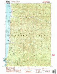
1984 Map of Heceta Head
USGS Topo · Published 1984About this map
Heceta Head Light House stands as a prominent landmark on this mid-1980s coastal survey, marking the jagged boundary between the Pacific Ocean and the coastal forests of Lane County. The landscape is defined by the massive footprint of the Siuslaw National Forest, which reaches the shoreline through a series of protected lands including Carl G Washburne Memorial State Park and Devils Elbow State Park. This era of management shows a heavy emphasis on conservation and public access, with numerous waysides like Stonefield Beach State Wayside and the Oregon Islands National Wildlife Refuge Wilderness protecting the rocky offshore knolls.
Find a feature on this map
49 named features on this map. Tap any name to fly to it.
Don’t see what you’re looking for? This feature index may not catch every label — zoom into the map to look around manually.
Map Details
Editions of this 1984 Heceta Head Map
2 editions found
Other maps of this area

1918 · Mapleton
USGS Topo · 1:48,000

1920 · Heceta Head
USGS Topo · 1:62,500

1922 · Waldport
USGS Topo · 1:62,500

1940 · Mapleton
USGS Topo · 1:62,500

1942 · Waldport
USGS Topo · 1:62,500

1942 · Heceta Head
USGS Topo · 1:62,500

1942 · Tidewater
USGS Topo · 1:62,500

1945 · Mapleton
USGS Topo · 1:62,500

1953 · Salem
USGS Topo · 1:250,000

1954 · Salem
USGS Topo · 1:250,000