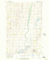
1956 Map of Hecla
USGS Topo · Published 1957About this map
Hecla serves as the primary hub of this prairie landscape during the mid-1950s, situated at the intersection of the Chicago and Northwestern railroad and local rural routes. The town is depicted with its Town Hall and essential civic infrastructure, while the surrounding plains are dotted with agricultural features such as flowing wells and the Bell Sch. The map straddles the state line between North Dakota and South Dakota, illustrating the transition between the townships of Port Emma, Lovell, Liberty Twp, and Hecla.
Find a feature on this map
19 named features on this map. Tap any name to fly to it.
Don’t see what you’re looking for? This feature index may not catch every label — zoom into the map to look around manually.
Map Details
Editions of this 1956 Hecla Map
This is the sole edition of this map. No revisions or reprints were ever made.
Other maps of this area

1894 · Hecla
USGS Topo · 1:62,500

1894 · Savo
USGS Topo · 1:62,500

1894 · Fullerton
USGS Topo · 1:62,500

1894 · Oakes
USGS Topo · 1:62,500

1895 · Lamoure
USGS Topo · 1:125,000

1896 · Columbia
USGS Topo · 1:125,000

1918 · La Moure
USGS Topo · 1:125,000

1953 · Jamestown
USGS Topo · 1:250,000

1953 · Hecla SE
USGS Topo · 1:24,000

1953 · Houghton
USGS Topo · 1:24,000