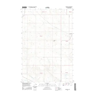
2017 Map of Hedgesville
USGS Topo · Published 2017About this map
Hedgesville sits as the primary settlement in this section of Wheatland County, situated near a distinctive bend where several drainage systems converge. The landscape is defined by the elevation of Haystack Butte, overlooking a network of ephemeral and perennial watercourses including Alkali Cr, Blake Cr, and Roberts Cr. To the south, the engineered path of the Deadmans Basin Supply Canal cuts across the terrain shortly before it meets the Musselshell River, reflecting the vital role of water management in this high-plains region. Rural connectivity is maintained through named tracks such as Lower Nihill Rd and Farmers Field Rd, which trace the section lines and topography of this ranching and agricultural territory during the early 21st century.
Find a feature on this map
18 named features on this map. Tap any name to fly to it.
Don’t see what you’re looking for? This feature index may not catch every label — zoom into the map to look around manually.
Map Details
Editions of this 2017 Hedgesville Map
This is the sole edition of this map. No revisions or reprints were ever made.
Other maps of this area

1889 · Big Snowy Mountain
USGS Topo · 1:250,000

1893 · Big Snowy Mountain
USGS Topo · 1:250,000

1954 · Roundup
USGS Topo · 1:250,000

1958 · Roundup
USGS Topo · 1:250,000

1986 · Shawmut
USGS Topo · 1:24,000

1986 · Halbert Creek South
USGS Topo · 1:24,000
1986 · Deadmans Basin Reservoir
USGS Topo · 1:24,000
1986 · Devils Pocket
USGS Topo · 1:24,000

1986 · Halbert Creek North
USGS Topo · 1:24,000
1986 · Oxford
USGS Topo · 1:24,000