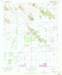
1957 Map of Hedgpeth Hills
USGS Topo · Published 1972About this map
Hedgpeth Hills and the Deem Hills dominate this portion of the northern Sonoran desert landscape during a period of accelerating suburban transition. While the northern reaches of the sheet near Biscuit Flat and Weir Valley remain largely open terrain defined by peaks like Pyramid Peak and East Wing Mountain, the southern sections show the expanding grid of Thunderbird Park and emerging neighborhoods around the Sierra Vista School.
Find a feature on this map
37 named features on this map. Tap any name to fly to it.
Don’t see what you’re looking for? This feature index may not catch every label — zoom into the map to look around manually.
Map Details
Editions of this 1957 Hedgpeth Hills Map
5 editions found
Other maps of this area

1954 · Phoenix
USGS Topo · 1:250,000

1957 · Phoenix
USGS Topo · 1:250,000

1957 · Calderwood Butte
USGS Topo · 1:24,000

1957 · El Mirage
USGS Topo · 1:24,000

1957 · Hedgpeth Hills
USGS Topo · 1:24,000

1957 · Glendale
USGS Topo · 1:24,000

1958 · Phoenix
USGS Topo · 1:250,000

1960 · Phoenix
USGS Topo · 1:250,000
1964 · Baldy Mtn
USGS Topo · 1:24,000
1964 · New River SE
USGS Topo · 1:24,000