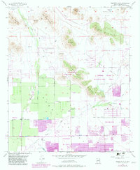
1957 Map of Hedgpeth Hills
USGS Topo · Published 1982About this map
Thunderbird Recreation Area and the surrounding Hedgpeth Hills dominate this mid-century look at the northern edge of the Salt River Valley. While northern sections like Biscuit Flat and Weir Valley remain largely undeveloped desert terrain, the southern portions of the sheet document the post-war expansion of Peoria, Glendale, and Phoenix. This era shows a landscape in transition, where traditional irrigation infrastructure like the Canal and numerous reservoirs meet the emerging suburban grid defined by Bell Road and Union Hills Drive.
Find a feature on this map
52 named features on this map. Tap any name to fly to it.
Don’t see what you’re looking for? This feature index may not catch every label — zoom into the map to look around manually.
Map Details
Editions of this 1957 Hedgpeth Hills Map
5 editions found
Other maps of this area

1954 · Phoenix
USGS Topo · 1:250,000

1957 · Phoenix
USGS Topo · 1:250,000

1957 · Calderwood Butte
USGS Topo · 1:24,000

1957 · El Mirage
USGS Topo · 1:24,000

1957 · Hedgpeth Hills
USGS Topo · 1:24,000

1957 · Glendale
USGS Topo · 1:24,000

1958 · Phoenix
USGS Topo · 1:250,000

1960 · Phoenix
USGS Topo · 1:250,000
1964 · Baldy Mtn
USGS Topo · 1:24,000
1964 · New River SE
USGS Topo · 1:24,000