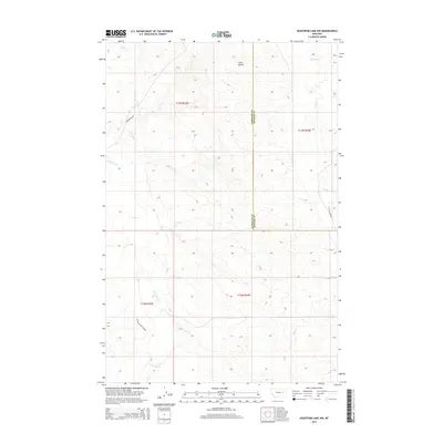
2014 Map of Hedstrom Lake NW
USGS Topo · Published 2014About this map
Twin Buttes rises as a prominent landmark in this corner of Eastern Montana, where the boundary between Garfield County and McCone County bisects the high plains. The landscape is defined by its complex drainage network, primarily focused on the winding path of Little Dry Creek and its many tributaries, including Jones Creek. This 2014 survey documents the continued importance of water management in this arid region, most notably seen in the Little Dry Users Ditch. A few established routes, such as Bollinger Road and Last Chance Road, provide the only primary access through the grid-like townships. The terrain is characterized by the subtle elevation changes of the Missouri Plateau, showing a territory dedicated to open range and sparse ranching infrastructure near the Dry Creek and Timber Creek drainages.
Find a feature on this map
13 named features on this map. Tap any name to fly to it.
Don’t see what you’re looking for? This feature index may not catch every label — zoom into the map to look around manually.
Map Details
Editions of this 2014 Hedstrom Lake NW Map
This is the sole edition of this map. No revisions or reprints were ever made.
Other maps of this area

1954 · Jordan
USGS Topo · 1:250,000

1956 · Jordan
USGS Topo · 1:250,000

1958 · Jordan
USGS Topo · 1:250,000

1964 · Jordan
USGS Topo · 1:250,000

1965 · Hedstrom Lake
USGS Topo · 1:24,000

1965 · Hedstrom Lake SE
USGS Topo · 1:24,000

1965 · Whiteside Ranch
USGS Topo · 1:24,000
1965 · Tree Coulee School
USGS Topo · 1:24,000

1965 · Hedstrom Lake NW
USGS Topo · 1:24,000
1965 · Sleepy Hollow
USGS Topo · 1:24,000