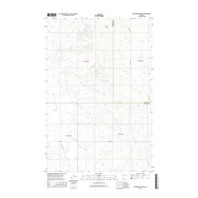
2017 Map of Hedstrom Lake NW
USGS Topo · Published 2017About this map
Little Dry Users Ditch winds through the southwestern corner of this landscape, representing the vital water infrastructure necessary for agriculture in the high plains of Eastern Montana. This 2017 survey documents the intersection of Garfield and McCone Counties, a region characterized by complex drainage patterns feeding into Little Dry Cr and Jones Cr. The elevation is punctuated by the prominent Twin Buttes in the northern reaches, serving as a significant topographical landmark above the surrounding coulees. Sparse transportation infrastructure, including the aptly named Last Chance Rd, S Flowing Wells Rd, and Two Furrows Rd, underscores the remote ranching character of this territory. The map provides a detailed view of the Public Land Survey System grid, including portions of t17n r43e and t16n r44e, which helps researchers trace the precise division of this rangeland.
Find a feature on this map
15 named features on this map. Tap any name to fly to it.
Don’t see what you’re looking for? This feature index may not catch every label — zoom into the map to look around manually.
Map Details
Editions of this 2017 Hedstrom Lake NW Map
This is the sole edition of this map. No revisions or reprints were ever made.
Other maps of this area

1954 · Jordan
USGS Topo · 1:250,000

1956 · Jordan
USGS Topo · 1:250,000

1958 · Jordan
USGS Topo · 1:250,000

1964 · Jordan
USGS Topo · 1:250,000

1965 · Hedstrom Lake
USGS Topo · 1:24,000

1965 · Hedstrom Lake SE
USGS Topo · 1:24,000

1965 · Whiteside Ranch
USGS Topo · 1:24,000
1965 · Tree Coulee School
USGS Topo · 1:24,000

1965 · Hedstrom Lake NW
USGS Topo · 1:24,000
1965 · Sleepy Hollow
USGS Topo · 1:24,000