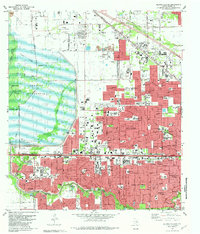
1982 Map of Hedwig Village
USGS Topo · Published 1982About this map
The Addicks Reservoir dominates the western landscape of this 1982 study, its massive Dam and basin providing critical flood control for the rapidly expanding Houston suburbs. East of the reservoir, the map documents a dense network of residential developments and municipal identities, including the villages of Bunker Hill Village, Hedwig Village, Hunters Creek Village, and Piney Point Village. This era represents a peak of suburban infrastructure, shown through a heavy concentration of educational facilities like Westchester High Sch and Stratford High Sch, alongside major commercial hubs like the Memorial City Shopping Center. Along the Buffalo Bayou and Whiteoak Bayou corridors, the land retains some of its riparian character even as industrial elements like Sandpits and the Southern Pacific rail line traverse the northern reaches near Fairbanks. Genealogists will find the Addicks Cem and Memorial Oaks Cem clearly marked among the residential blocks.
Find a feature on this map
85 named features on this map. Tap any name to fly to it.
Don’t see what you’re looking for? This feature index may not catch every label — zoom into the map to look around manually.
Map Details
Editions of this 1982 Hedwig Village Map
2 editions found
Other maps of this area

1915 · Bellaire
USGS Topo · 1:24,000

1915 · Houston Heights
USGS Topo · 1:24,000

1915 · Alief
USGS Topo · 1:24,000

1915 · Cypress
USGS Topo · 1:24,000

1915 · Addicks
USGS Topo · 1:24,000

1915 · Hillendahl
USGS Topo · 1:24,000

1915 · Clodine
USGS Topo · 1:24,000

1916 · Aldine
USGS Topo · 1:24,000

1916 · Satsuma
USGS Topo · 1:24,000

1918 · Cypress
USGS Topo · 1:31,680
Featured Places
- Houston, TX
- Jersey Village, TX
- Hunters Creek Village, TX
- Bunker Hill Village, TX
- Spring Valley Village, TX