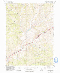
1991 Map of Heiners Creek
USGS Topo · Published 1991About this map
Echo Canyon serves as a primary corridor through this part of Summit County, where the high-altitude landscape is defined by a dense network of drainages and springs. The map shows the convergence of Heiners Creek and its South Fork as they flow toward the canyon bottom. This area, updated from aerial photography and field checks in the late 1980s, highlights the essential role of water in the high desert, evidenced by named points like Spring Emory and Mud Spring. Smaller tributaries like Fish Creek and Grass Valley Creek carve through the complex topography, while named canyons such as Thirtyfive Canyon and Stag Canyon branch off the main thoroughfare. An aqueduct and various water tanks underscore the engineered efforts to manage these resources in a region characterized by prominent peaks like Deseret.
Find a feature on this map
27 named features on this map. Tap any name to fly to it.
Don’t see what you’re looking for? This feature index may not catch every label — zoom into the map to look around manually.
Map Details
Editions of this 1991 Heiners Creek Map
This is the sole edition of this map. No revisions or reprints were ever made.
Other maps of this area

1885 · Salt Lake
USGS Topo · 1:250,000

1900 · Coalville
USGS Topo · 1:125,000

1903 · Coalville
USGS Topo · 1:125,000

1954 · Salt Lake City
USGS Topo · 1:250,000

1954 · Ogden
USGS Topo · 1:250,000

1958 · Ogden
USGS Topo · 1:250,000

1958 · Salt Lake City
USGS Topo · 1:250,000

1960 · Ogden
USGS Topo · 1:250,000

1960 · Salt Lake City
USGS Topo · 1:250,000

1964 · Lost Creek Dam
USGS Topo · 1:24,000