
2023 Map of Heislerville
USGS Topo · Published 2023About this map
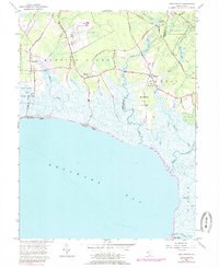
Delaware Bay defines the southern reach of this coastal landscape, where the tidal wetlands of the Cumberland Co and Cape May Co border are intersected by numerous waterways like Dennis Creek and Bidwell Creek. Small settlements such as Leesburg, Delmont, and Heislerville are concentrated in the northern, more elevated sections of the quadrangle. Local history and genealogy are centered around sites like the Heislerville Methodist Church Cem and West Creek Baptist Cem, which sit near the northern edge of the marshlands. Along the bay shoreline, the map identifies remote waterfront areas including Thompsons Beach and Moores Beach, connected to the interior by long, narrow roads such as Thompson Beach Rd. The presence of Pickle Factory Pond and Stipson Island reflects the region's reliance on both its aqueous environment and its small-scale industrial history, while a network of rural routes like N Delsea Dr facilitates travel between these secluded coastal hamlets.
Find a feature on this map
57 named features on this map. Tap any name to fly to it.
Don’t see what you’re looking for? This feature index may not catch every label — zoom into the map to look around manually.
Map Details
Editions of this 2023 Heislerville Map
This is the sole edition of this map. No revisions or reprints were ever made.
Historical Maps of Eldora Through Time
Featured Locations
- Dennis Township, NJ
- Middle Township, NJ
- Maurice River Township, NJ
- Heislerville, Maurice River Township
- Eldora, Dennis Township