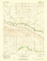
1960 Map of Heizer
USGS Topo · Published 1961About this map
Walnut Creek and its serpentine meanders dominate this Central Kansas landscape, reflecting the agricultural and industrial character of the region in the mid-20th century. The settlement of Heizer serves as a local hub along the Atchison Topeka and Santa Fe railroad, while the Missouri Pacific line skirts the northern reaches. This 1960 survey captures the rural infrastructure of Walnut and Eureka townships, documenting several Oil Wells that signify the area's energy development alongside established family farms. Local history is anchored by essential community landmarks including Walnut Ridge Sch and Pleasant View Sch, which appear near generational resting places like Patterson Cem and Everett Cem. The detailed topography shows the transition between the fertile creek bottoms and the higher plains, evidenced by Dry Walnut Creek and Book Creek.
Find a feature on this map
18 named features on this map. Tap any name to fly to it.
Don’t see what you’re looking for? This feature index may not catch every label — zoom into the map to look around manually.
Map Details
Editions of this 1960 Heizer Map
This is the sole edition of this map. No revisions or reprints were ever made.
Other maps of this area

1889 · Larned
USGS Topo · 1:125,000

1891 · Great Bend
USGS Topo · 1:125,000

1891 · Larned
USGS Topo · 1:125,000

1893 · Great Bend
USGS Topo · 1:125,000

1896 · Russell
USGS Topo · 1:125,000

1896 · Hays
USGS Topo · 1:125,000

1955 · Great Bend
USGS Topo · 1:250,000

1957 · Great Bend
USGS Topo · 1:250,000

1958 · Great Bend
USGS Topo · 1:250,000

1958 · Great Bend
USGS Topo · 1:24,000