1957 Map of Helen
USGS Topo · Published 1983About this map
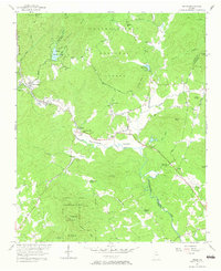
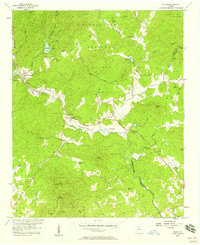
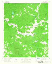
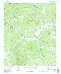
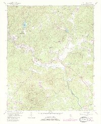
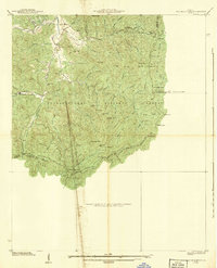
The Nacoochee Valley landscape is defined by the headwaters of the Chattahoochee River as it flows south through White County. This 1957 field-checked survey highlights the early 20th-century development of Helen and Robertstown, positioned near the entrance to Unicoi State Park. The map documents a significant archaeological and historical corridor along the Unicoi Turnpike, notably featuring the Indian Mound and the Crescent Hill Ch in the Nacoochee area. The settlement pattern is largely focused along the valley floors of Sautee Creek and Dukes Creek, where numerous small community centers like Sautee are marked by rural landmarks such as the White Ch and Bean Creek Ch. Topographically, the area is hemmed in by prominent peaks including Yonah Mtn and Lynch Mtn, while the Chattahoochee National Forest encompasses the northern ridges.
Find a feature on this map
51 named features on this map. Tap any name to fly to it.
Don’t see what you’re looking for? This feature index may not catch every label — zoom into the map to look around manually.
Map Details
Editions of this 1957 Helen Map
5 editions found
Other maps of this area

1886 · Dahlonega
USGS Topo · 1:125,000

1892 · Dahlonega
USGS Topo · 1:125,000

1896 · Dahlonega
USGS Topo · 1:125,000

1903 · Dahlonega
USGS Topo · 1:125,000
1935 · Cowrock
USGS Topo · 1:24,000
1935 · Tray Mountain
USGS Topo · 1:24,000

1935 · Jacks Gap
USGS Topo · 1:24,000
1938 · Cowrock
USGS Topo · 1:24,000

1938 · Jacks Gap
USGS Topo · 1:24,000
1938 · Tray Mountain
USGS Topo · 1:24,000