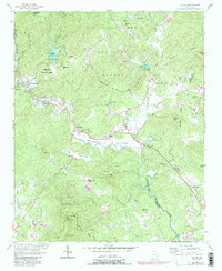
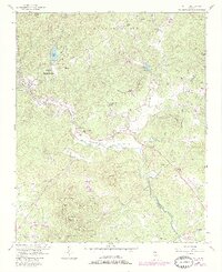
1957 Map of Helen
USGS Topo · Published 1986About this map
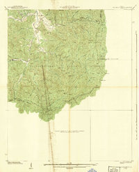
Nacoochee Valley's historic landscape is defined by the winding course of the Chattahoochee River and the ancient presence of an Indian Mound near Crescent Hill Ch. This mid-century survey captures the region as it transitions from the forested slopes of the Chattahoochee National Forest to the small agricultural and mountain communities of Helen, Sautee, and Robertstown. The road network is anchored by the historic Unicoi Turnpike, which parallels the river, while the high ground is marked by prominent peaks such as Yonah Mtn and Sal Mtn. The map preserves the locations of numerous local landmarks, including Sky Lake (Girl Scout Camp) and several rural religious sites like Union Grove Chapel and Bean Creek Ch. This record shows a period of early recreation development at Unicoi State Park and Unicoi Lake before more modern expansion arrived.
Find a feature on this map
50 named features on this map. Tap any name to fly to it.
Don’t see what you’re looking for? This feature index may not catch every label — zoom into the map to look around manually.
Map Details
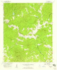
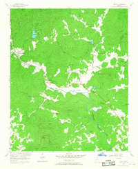
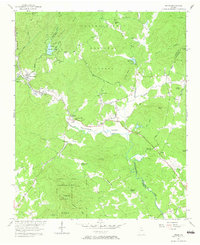
Editions of this 1957 Helen Map
5 editions found
Other maps of this area

1886 · Dahlonega
USGS Topo · 1:125,000

1892 · Dahlonega
USGS Topo · 1:125,000

1896 · Dahlonega
USGS Topo · 1:125,000

1903 · Dahlonega
USGS Topo · 1:125,000
1935 · Cowrock
USGS Topo · 1:24,000
1935 · Tray Mountain
USGS Topo · 1:24,000

1935 · Jacks Gap
USGS Topo · 1:24,000
1938 · Cowrock
USGS Topo · 1:24,000

1938 · Jacks Gap
USGS Topo · 1:24,000
1938 · Tray Mountain
USGS Topo · 1:24,000