Loading...
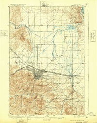
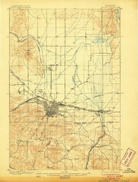
Loading map...1899 Map of Helena and Vicinity
USGS Topo · Published 1932About this map
Helena serves as the focal point of this late 19th-century landscape, positioned at the convergence of several major mountain drainages and rail lines. The city is flanked by Mount Helena and Mount Ascension, with the Helena National Forest extending to the south. The industrial and educational foundations of the territorial capital are evident in the presence of the University north of the city center and a dense network of railroads including the Northern Pacific R.R. Main Line and the Great Northern Railway Montana Central Div.
Find a feature on this map
38 named features on this map. Tap any name to fly to it.
Don’t see what you’re looking for? This feature index may not catch every label — zoom into the map to look around manually.
Map Details
Date Portrayed1899
Date Published1932
PublisherU.S. Geological Survey
Map TypeTopographic
Scale1:62,500
Physical Dimensions15.7 x 19.9 inches
Editions of this 1899 Helena and Vicinity Map
3 editions found

Historical Maps of Helena Through Time
Featured Locations
Source Details
SourceU.S. Geological Survey
CopyrightPublic Domain