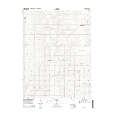
2014 Map of Helena
USGS Topo · Published 2014About this map
Helena and the surrounding Andrew County countryside are defined by the winding course of the Platte River and its numerous tributaries. This survey captures the rural character of northwest Missouri, where small settlements like Fountainbleau and Rochester are connected by a dense grid of county roads. The landscape is deeply incised by water, with Niagara Cr, Muddy Cr, and Long Br carving through the terrain. A notable geographic landmark, Rochester Falls, sits just southwest of its namesake village, while the Bedford Chapel Cemetery in the northwestern corner serves as a significant site for local genealogical research. The presence of a Wire Bridge across a tributary northeast of Fountainbleau highlights the local engineering used to navigate this river-dissected topography during the early 21st century.
Find a feature on this map
70 named features on this map. Tap any name to fly to it.
Don’t see what you’re looking for? This feature index may not catch every label — zoom into the map to look around manually.
Map Details
Editions of this 2014 Helena Map
This is the sole edition of this map. No revisions or reprints were ever made.
Other maps of this area
1923 · Clarksdale
USGS Topo · 1:62,500
1924 · St. Joseph
USGS Topo · 1:62,500
1925 · Clarksdale
USGS Topo · 1:62,500
1925 · Stanberry
USGS Topo · 1:62,500
1926 · Saint Joseph
USGS Topo · 1:62,500
1927 · Bolckow
USGS Topo · 1:62,500
1939 · Stanberry
USGS Topo · 1:62,500
1943 · Stanberry
USGS Topo · 1:62,500
1945 · Bolckow
USGS Topo · 1:62,500
1950 · Kansas City
USGS Topo · 1:250,000