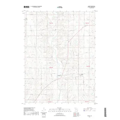
2017 Map of Helena
USGS Topo · Published 2017About this map
The Platte River meanders through this portion of Andrew County, defining the local landscape with its sharp bends and tributary systems. The settlement of Rochester is situated near a prominent bend where the river meets Niagara Cr, not far from the Rochester Falls. This area showcases a transitional rural character, where the river valley provided a natural corridor for early development and transportation. To the east, the community of Helena serves as a secondary node within a network of county roads. Genealogical interest is centered on the northwest at Bedford Chapel Cem. Further north, a Wire Bridge spans the river, indicating historical crossing points that predated modern infrastructure. The map also records several significant creek systems, including Muddy Cr and Long Br, which drain the surrounding agricultural uplands into the central river basin.
Find a feature on this map
71 named features on this map. Tap any name to fly to it.
Don’t see what you’re looking for? This feature index may not catch every label — zoom into the map to look around manually.
Map Details
Editions of this 2017 Helena Map
This is the sole edition of this map. No revisions or reprints were ever made.
Other maps of this area
1923 · Clarksdale
USGS Topo · 1:62,500
1924 · St. Joseph
USGS Topo · 1:62,500
1925 · Clarksdale
USGS Topo · 1:62,500
1925 · Stanberry
USGS Topo · 1:62,500
1926 · Saint Joseph
USGS Topo · 1:62,500
1927 · Bolckow
USGS Topo · 1:62,500
1939 · Stanberry
USGS Topo · 1:62,500
1943 · Stanberry
USGS Topo · 1:62,500
1945 · Bolckow
USGS Topo · 1:62,500
1950 · Kansas City
USGS Topo · 1:250,000