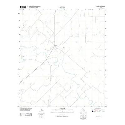
2010 Map of Helena
USGS Topo · Published 2010About this map
Helena serves as the focal point of this South Texas landscape, situated at a junction where rural routes like N FM 81 Rd meet. The settlement is defined by its proximity to the meandering San Antonio River, which snakes through the southern portion of the quadrangle. This area of Karnes County is characterized by a dense network of seasonal and perennial waterways, including Ecleto Creek, McTennel Creek, and Cibolo Creek, which together drain the surrounding ranchland. Genealogists and local historians will find the Helena Cemetery positioned just east of the main townsite, providing a primary record of the community's ancestral roots. To the west, the elevation rises toward Lookout Hill, one of the few prominent topographic markers in this river valley terrain. The infrastructure of the early 21st century is represented by a web of county roads, such as Wofford Crossing Rd, tracing the paths of earlier livestock and transport routes.
Find a feature on this map
33 named features on this map. Tap any name to fly to it.
Don’t see what you’re looking for? This feature index may not catch every label — zoom into the map to look around manually.
Map Details
Editions of this 2010 Helena Map
This is the sole edition of this map. No revisions or reprints were ever made.
Other maps of this area

1920 · Smiley
USGS Topo · 1:125,000

1953 · Beeville
USGS Topo · 1:250,000

1953 · Seguin
USGS Topo · 1:250,000

1956 · Beeville
USGS Topo · 1:250,000

1956 · Karnes City
USGS Topo · 1:62,500

1958 · Seguin
USGS Topo · 1:250,000

1960 · Beeville
USGS Topo · 1:250,000
1960 · Karnes City
USGS Topo · 1:24,000

1960 · Kosciusko
USGS Topo · 1:24,000

1960 · Helena
USGS Topo · 1:24,000