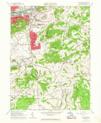
1965 Map of Hellertown
USGS Topo · Published 1967About this map
The Lehigh River flows through the northern industrial corridor of this mid-1960s survey, anchoring the urban development of Bethlehem and South Terrace. The landscape transition from heavy industrial infrastructure, including a prominent powerplant and multiple substations, into the borough of Hellertown reveals a dense network of civic and religious institutions. Local landmarks like the Lost River Caverns and the Ymca sit alongside numerous parochial schools such as St Michaels Sch and St Theresa Sch.
Find a feature on this map
92 named features on this map. Tap any name to fly to it.
Don’t see what you’re looking for? This feature index may not catch every label — zoom into the map to look around manually.
Map Details
Editions of this 1965 Hellertown Map
4 editions found
Other maps of this area

1888 · Quakertown
USGS Topo · 1:62,500

1890 · Easton
USGS Topo · 1:62,500

1890 · Doylestown
USGS Topo · 1:62,500

1890 · Quakertown
USGS Topo · 1:62,500

1891 · Easton
USGS Topo · 1:62,500

1891 · Doylestown
USGS Topo · 1:62,500

1894 · Allentown
USGS Topo · 1:62,500

1894 · Quakertown
USGS Topo · 1:62,500

1932 · Easton
USGS Topo · 1:62,500

1939 · Allentown
USGS Topo · 1:62,500
Featured Places
- Bethlehem, PA
- Lower Saucon Township, PA
- Durham Township, PA
- Haycock Township, PA
- Specktown, Lower Saucon Township