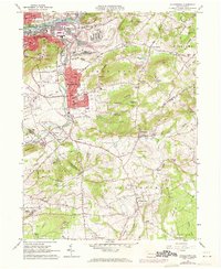
1965 Map of Hellertown
USGS Topo · Published 1972About this map
Lehigh River and the industrial corridor of Bethlehem dominate the northern portion of this 1965 survey, where the Lehigh Canal runs parallel to major rail lines including the Lehigh Valley RR and Central RR of New Jersey. The landscape quickly transitions from the urban density of South Terrace and the Lehigh University campus to the valley of Saucon Creek. Here, the borough of Hellertown serves as a hub, known for the Lost River Caverns and surrounded by a network of smaller crossroads like Bingen, Leithsville, and Springtown. Significant land use includes numerous quarries and the sprawling Saucon Park. The rural character of Lower Saucon and Springfield is punctuated by historic community centers such as the Slovak Cem and Salem Sch, reflecting the deep-rooted immigrant and agrarian heritage of the Northampton and Bucks County borderlands.
Find a feature on this map
108 named features on this map. Tap any name to fly to it.
Don’t see what you’re looking for? This feature index may not catch every label — zoom into the map to look around manually.
Map Details
Editions of this 1965 Hellertown Map
4 editions found
Other maps of this area

1888 · Quakertown
USGS Topo · 1:62,500

1890 · Easton
USGS Topo · 1:62,500

1890 · Doylestown
USGS Topo · 1:62,500

1890 · Quakertown
USGS Topo · 1:62,500

1891 · Easton
USGS Topo · 1:62,500

1891 · Doylestown
USGS Topo · 1:62,500

1894 · Allentown
USGS Topo · 1:62,500

1894 · Quakertown
USGS Topo · 1:62,500

1932 · Easton
USGS Topo · 1:62,500

1939 · Allentown
USGS Topo · 1:62,500
Featured Places
- Bethlehem, PA
- Lower Saucon Township, PA
- Durham Township, PA
- Haycock Township, PA
- Specktown, Lower Saucon Township