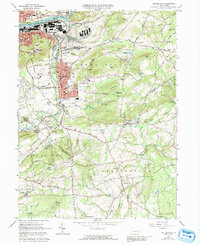
1965 Map of Hellertown
USGS Topo · Published 1992About this map
The industrial and academic corridor of Bethlehem and Hellertown is captured here during a period of transition, where the heavy infrastructure along the Lehigh River meets the expanding campus of Lehigh University. The northern reaches are dominated by the Lehigh Canal and dense residential blocks like South Terrace, while the southern landscapes of Lower Saucon and Springfield remain more dispersed. A notable geological landmark, Lost River Caverns, is situated near the heart of Hellertown, highlighting the unique subterranean features of the Saucon Valley. Farther south, the map reveals a collection of smaller settlements such as Springtown, Pleasant Valley, and Leithsville, many of which grew around early rural churches like St Johns Ch and schools like the Salem Sch. The map tracks the expansion of Interstate 78 & U.S. 22 as it bypasses the older town centers, signaling the shift in regional transportation during the mid-20th century.
Find a feature on this map
102 named features on this map. Tap any name to fly to it.
Don’t see what you’re looking for? This feature index may not catch every label — zoom into the map to look around manually.
Map Details
Editions of this 1965 Hellertown Map
4 editions found
Other maps of this area

1888 · Quakertown
USGS Topo · 1:62,500

1890 · Easton
USGS Topo · 1:62,500

1890 · Doylestown
USGS Topo · 1:62,500

1890 · Quakertown
USGS Topo · 1:62,500

1891 · Easton
USGS Topo · 1:62,500

1891 · Doylestown
USGS Topo · 1:62,500

1894 · Allentown
USGS Topo · 1:62,500

1894 · Quakertown
USGS Topo · 1:62,500

1932 · Easton
USGS Topo · 1:62,500

1939 · Allentown
USGS Topo · 1:62,500
Featured Places
- Bethlehem, PA
- Lower Saucon Township, PA
- Durham Township, PA
- Haycock Township, PA
- Specktown, Lower Saucon Township