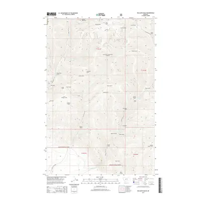
2014 Map of Hellgate Gulch
USGS Topo · Published 2014About this map
The Big Belt Mountains dominate this section of the Helena National Forest, where a complex network of drainages has carved deep into the Montana landscape. Named gulches define the local geography, linked by a system of primitive roads including Magpie Gulch Rd, Hellgate Gulch Rd, and Avalanche Gulch Rd. The sheer density of named topographic features—from the evocative Never Sweat Gulch and Sheriff Gulch to the smaller Little Hellgate Gulch—reflects the history of early mining and prospecting in these high-elevation corridors. Waterways such as Magpie Cr, Grouse Cr, and Avalanche Cr provide the primary drainage for the area. The map illustrates a landscape largely untouched by modern urbanization, preserved as public land where surveyors have recorded local landmarks like Quartz Gulch and Carpenter Gulch alongside township and range boundaries such as t11n r1e and t10n r1e.
Find a feature on this map
43 named features on this map. Tap any name to fly to it.
Don’t see what you’re looking for? This feature index may not catch every label — zoom into the map to look around manually.
Map Details
Editions of this 2014 Hellgate Gulch Map
This is the sole edition of this map. No revisions or reprints were ever made.
Other maps of this area
1886 · Fort Logan
USGS Topo · 1:250,000
1948 · White Sulphur Springs
USGS Topo · 1:250,000
1950 · Canyon Ferry
USGS Topo · 1:62,500
1958 · White Sulphur Springs
USGS Topo · 1:250,000
1961 · White Sulphur Springs
USGS Topo · 1:250,000
1962 · Hogback Mountain
USGS Topo · 1:24,000
1962 · Snedaker Basin
USGS Topo · 1:24,000
1965 · White Sulphur Springs
USGS Topo · 1:250,000
1966 · Diamond City
USGS Topo · 1:24,000
1966 · Lingshire
USGS Topo · 1:24,000