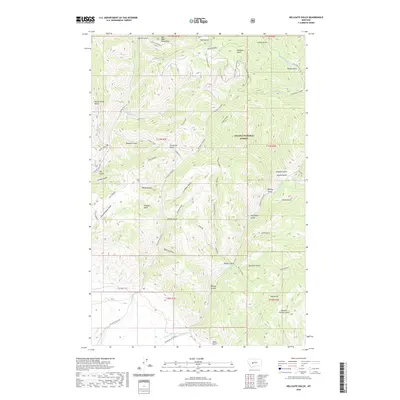
2020 Map of Hellgate Gulch
USGS Topo · Published 2020About this map
The Big Belt Mountains dominate this landscape within the Helena National Forest, where a complex network of drainages and high ridges defines the terrain. Prominent landmarks such as Hellgate Ridge and Thompson Hellgate speak to the dramatic topography of the region. The map reveals an intricate system of named gulches, including Kilgallon Gulch, Harris Gulch, and Never Sweat Gulch, which feed into primary watercourses like Avalanche Cr and Magpie Cr. This area is characterized by its absence of major settlements, instead showing a network of forest access routes like Magpie Gulch Rd and Hellgate Gulch Rd. The presence of the Frontage Trail and various creek-side tracks highlights the primitive transportation corridors that have long served this part of the Montana wilderness.
Find a feature on this map
50 named features on this map. Tap any name to fly to it.
Don’t see what you’re looking for? This feature index may not catch every label — zoom into the map to look around manually.
Map Details
Editions of this 2020 Hellgate Gulch Map
This is the sole edition of this map. No revisions or reprints were ever made.
Other maps of this area
1886 · Fort Logan
USGS Topo · 1:250,000
1948 · White Sulphur Springs
USGS Topo · 1:250,000
1950 · Canyon Ferry
USGS Topo · 1:62,500
1958 · White Sulphur Springs
USGS Topo · 1:250,000
1961 · White Sulphur Springs
USGS Topo · 1:250,000
1962 · Hogback Mountain
USGS Topo · 1:24,000
1962 · Snedaker Basin
USGS Topo · 1:24,000
1965 · White Sulphur Springs
USGS Topo · 1:250,000
1966 · Diamond City
USGS Topo · 1:24,000
1966 · Lingshire
USGS Topo · 1:24,000