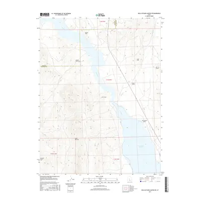
2017 Map of Hells Kitchen Canyon SW
USGS Topo · Published 2017About this map
Sevier Bridge Reservoir dominates the eastern landscape of this Sanpete County terrain, where the waters of the Sevier River are impounded against a backdrop of deep canyons and ridges. The topography is defined by the eastern slopes of the Valley Mountains, which give way to a series of named drainages including Hells Kitchen Canyon, Red Canyon, and Timber Canyon. Notable landmarks such as the Painted Rocks and Painted Rock Canyon provide distinct navigational points along the western shore of the river. The map also delineates the boundary between Juab and Sanpete counties, cutting through the high country where local cattle and sheep ranchers have long utilized grazing grounds like Dick and Dalton Flat and Flat Canyon. The drainage of Maple Cr flows from the northeast, contributing to the complex water system that has historically supported agriculture in the surrounding valleys.
Find a feature on this map
14 named features on this map. Tap any name to fly to it.
Don’t see what you’re looking for? This feature index may not catch every label — zoom into the map to look around manually.
Map Details
Editions of this 2017 Hells Kitchen Canyon SW Map
This is the sole edition of this map. No revisions or reprints were ever made.
Other maps of this area
1885 · Manti
USGS Topo · 1:250,000

1885 · Sevier Desert
USGS Topo · 1:250,000
1895 · Manti
USGS Topo · 1:250,000
1952 · Scipio North
USGS Topo · 1:62,500

1953 · Delta
USGS Topo · 1:250,000
1956 · Price
USGS Topo · 1:250,000

1958 · Delta
USGS Topo · 1:250,000
1960 · Price
USGS Topo · 1:250,000
1962 · Price
USGS Topo · 1:250,000

1962 · Delta
USGS Topo · 1:250,000