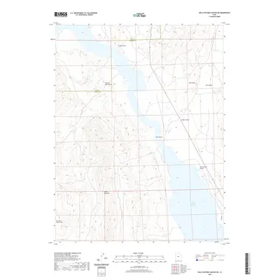
2020 Map of Hells Kitchen Canyon SW
USGS Topo · Published 2020About this map
Sevier Bridge Reservoir dominates the eastern basin of this landscape, its waters meeting the steep western slopes of the Valley Mountains. This 2020 survey illustrates the complex drainage and erosion patterns of the central Utah desert, where canyons like Hells Kitchen Canyon, Red Canyon, and Timber Canyon carve into the elevated plateaus. The Juab and Sanpete county line bisects the northern reaches near Painted Rocks, a notable landmark overlooking the reservoir. Further west, the terrain levels out into the Dick and Dalton Flat, providing a contrast to the high, rugged crests of Cedar Ridge. The map details the seasonal flow of Maple Cr and the topographical prominence of Painted Rock Canyon, offering a precise record of the shoreline and high-desert landforms.
Find a feature on this map
12 named features on this map. Tap any name to fly to it.
Don’t see what you’re looking for? This feature index may not catch every label — zoom into the map to look around manually.
Map Details
Editions of this 2020 Hells Kitchen Canyon SW Map
This is the sole edition of this map. No revisions or reprints were ever made.
Other maps of this area
1885 · Manti
USGS Topo · 1:250,000

1885 · Sevier Desert
USGS Topo · 1:250,000
1895 · Manti
USGS Topo · 1:250,000
1952 · Scipio North
USGS Topo · 1:62,500

1953 · Delta
USGS Topo · 1:250,000
1956 · Price
USGS Topo · 1:250,000

1958 · Delta
USGS Topo · 1:250,000
1960 · Price
USGS Topo · 1:250,000
1962 · Price
USGS Topo · 1:250,000

1962 · Delta
USGS Topo · 1:250,000