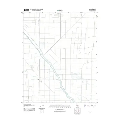
2012 Map of Helm
USGS Topo · Published 2012About this map
Fresno Slough meanders through this agricultural landscape in the San Joaquin Valley, serving as a central hydrological feature alongside the Stinson Canal and the James Bypass. The settlement of Helm is situated near the junction of several primary roads, reflecting the grid-based development typical of California's central farming regions. This 2012 survey illustrates a complex network of irrigation and transportation, where named routes like S McMullin Grade and Colorado Rd cut across the valley floor. The map documents the meticulous management of water and land that sustains the area's productive fields. Local historians and genealogists can trace the intersection of specific family-named avenues and roads that define the rural infrastructure of Fresno County at this time.
Find a feature on this map
31 named features on this map. Tap any name to fly to it.
Don’t see what you’re looking for? This feature index may not catch every label — zoom into the map to look around manually.
Map Details
Editions of this 2012 Helm Map
This is the sole edition of this map. No revisions or reprints were ever made.
Other maps of this area

1912 · Coalinga
USGS Topo · 1:125,000

1923 · Kearney Park
USGS Topo · 1:31,680

1924 · Jamesan
USGS Topo · 1:31,680

1925 · Helm
USGS Topo · 1:31,680

1925 · San Joaquin
USGS Topo · 1:31,680

1925 · Raisin
USGS Topo · 1:31,680

1927 · Burrel
USGS Topo · 1:31,680

1931 · Wheatville
USGS Topo · 1:31,680

1931 · Towne Oil Station
USGS Topo · 1:31,680
1946 · Kearney Park
USGS Topo · 1:24,000