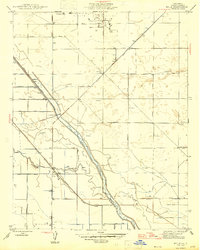
1947 Map of Helm
USGS Topo · Published 1947About this map
Helm sits at the junction of the Southern Pacific railroad and a grid of rural agricultural roads, serving as a vital transport hub for the central San Joaquin Valley in the late 1940s. The landscape is defined by its extensive water management system, centered on the Fresno Slough and Fish Slough. The presence of the Diversion Dam and the Fresno Slough Bypass highlights the engineering required to control regional irrigation and drainage. To the north, the Raisin City Oil Fields introduce industrial extraction to the predominantly agricultural terrain. This survey captures a moment when the valley's economy relied on a precise network of siphons, windmills, and canals like the Stinson Canal to sustain its growth.
Find a feature on this map
29 named features on this map. Tap any name to fly to it.
Don’t see what you’re looking for? This feature index may not catch every label — zoom into the map to look around manually.
Map Details
Editions of this 1947 Helm Map
This is the sole edition of this map. No revisions or reprints were ever made.
Other maps of this area

1912 · Coalinga
USGS Topo · 1:125,000

1923 · Kearney Park
USGS Topo · 1:31,680

1924 · Jamesan
USGS Topo · 1:31,680

1925 · Helm
USGS Topo · 1:31,680

1925 · San Joaquin
USGS Topo · 1:31,680

1925 · Raisin
USGS Topo · 1:31,680

1927 · Burrel
USGS Topo · 1:31,680

1931 · Wheatville
USGS Topo · 1:31,680

1931 · Towne Oil Station
USGS Topo · 1:31,680
1946 · Kearney Park
USGS Topo · 1:24,000