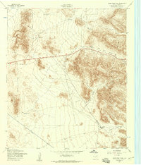
1955 Map of Helms West Well
USGS Topo · Published 1959About this map
Hueco Mountains topography dominates this mid-century desert landscape in El Paso County, where survival was dictated by the strategic placement of water resources. The map documents a network of livestock tanks and catchment basins vital to ranching operations, such as Middle Tank, Dugout Tank, and Pow Wow Tank. These features are scattered across the high desert flats and within the shadows of prominent terrain features like Pow Wow Canyon and Martin Canyon.
Find a feature on this map
14 named features on this map. Tap any name to fly to it.
Don’t see what you’re looking for? This feature index may not catch every label — zoom into the map to look around manually.
Map Details
Editions of this 1955 Helms West Well Map
This is the sole edition of this map. No revisions or reprints were ever made.
Other maps of this area

1896 · El Paso
USGS Topo · 1:125,000

1903 · Cerro Alto
USGS Topo · 1:125,000

1908 · El Paso
USGS Topo · 1:125,000

1939 · Heuco Tanks
USGS Topo · 1:62,500

1940 · Heuco Tanks
USGS Topo · 1:62,500

1941 · Clint
USGS Topo · 1:62,500

1941 · Heuco Mountains
USGS Topo · 1:62,500

1942 · Borrego
USGS Topo · 1:62,500

1943 · Heuco Mountains
USGS Topo · 1:62,500

1944 · Heuco Tanks
USGS Topo · 1:62,500
Featured Places
- Butterfield City Number 4 Colonia, TX
- Butterfield City Number 1 Colonia, TX
- Hueco Mountain Estates Number 9 Colonia, TX
- Butterfield, TX
- Butterfield City Number 2 Colonia, TX