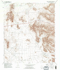
1995 Map of Helms West Well
USGS Topo · Published 1995About this map
The Hueco Mountains dominate the eastern landscape of this West Texas region, where the arid environment necessitated a complex system of water management. The terrain is defined by rugged elevation changes, particularly through Powwow Canyon and Martin Canyon, which provide natural drainage routes toward the flats below. Water security for ranching or transit is marked by a series of named catchments such as Mikes Tank, Noble Tank, and Hidden Tank. Near the southern edge of the mountains, the Helms West Well (Site) serves as a primary landmark in a landscape otherwise punctuated by industrial activity. Several Quarry and Gravel Pit operations are located along the western foothills, while a network of pipelines and the shared route of 62 180 cut across the desert floor. The vast Fourmile Draw provides a geographic anchor for the southern reaches of the quadrangle.
Find a feature on this map
19 named features on this map. Tap any name to fly to it.
Don’t see what you’re looking for? This feature index may not catch every label — zoom into the map to look around manually.
Map Details
Editions of this 1995 Helms West Well Map
This is the sole edition of this map. No revisions or reprints were ever made.
Other maps of this area

1896 · El Paso
USGS Topo · 1:125,000

1903 · Cerro Alto
USGS Topo · 1:125,000

1908 · El Paso
USGS Topo · 1:125,000

1939 · Heuco Tanks
USGS Topo · 1:62,500

1940 · Heuco Tanks
USGS Topo · 1:62,500

1941 · Clint
USGS Topo · 1:62,500

1941 · Heuco Mountains
USGS Topo · 1:62,500

1942 · Borrego
USGS Topo · 1:62,500

1943 · Heuco Mountains
USGS Topo · 1:62,500

1944 · Heuco Tanks
USGS Topo · 1:62,500
Featured Places
- Butterfield City Number 4 Colonia, TX
- Butterfield City Number 1 Colonia, TX
- Hueco Mountain Estates Number 9 Colonia, TX
- Butterfield, TX
- Butterfield City Number 2 Colonia, TX