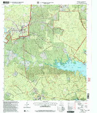
2003 Map of Hemphill
USGS Topo · Published 2004About this map
The county seat of Hemphill stands as a focal point in this eastern Texas landscape, where municipal life meets the dense woodlands of the Sabine National Forest. Published in the early 2000s, the map illustrates the transition from the structured street grids of Hemphill and East Mayfield into the sprawling Indian Mounds Wilderness to the east. The terrain is deeply carved by waterways like Housen Bayou and Hurricane Bayou, which drain into the significant expanse of the Toledo Bend Reservoir along the southern margin.
Find a feature on this map
59 named features on this map. Tap any name to fly to it.
Don’t see what you’re looking for? This feature index may not catch every label — zoom into the map to look around manually.
Map Details
Editions of this 2003 Hemphill Map
This is the sole edition of this map. No revisions or reprints were ever made.
Other maps of this area

1944 · Negreet
USGS Topo · 1:62,500

1944 · Wiergate
USGS Topo · 1:62,500

1948 · Wiergate
USGS Topo · 1:62,500

1953 · Alexandria
USGS Topo · 1:250,000

1954 · Columbus
USGS Topo · 1:24,000

1954 · Fairdale
USGS Topo · 1:24,000

1954 · Negreet
USGS Topo · 1:62,500

1954 · Wiergate
USGS Topo · 1:62,500

1954 · Salter Creek
USGS Topo · 1:24,000

1955 · Alexandria
USGS Topo · 1:250,000