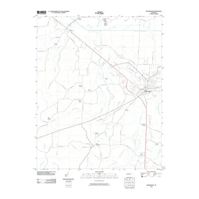
2010 Map of Henderson
USGS Topo · Published 2010About this map
Pinson Indian Mounds and the prominent Great Central Mound anchor the northern landscape of this region, providing a glimpse into the ancient pre-settlement history of West Tennessee. The city of Henderson serves as the primary hub, where the Henderson Post Office and Henderson Cemetery mark the community's core along the corridor of the South Fork Forked Deer River. This 2010 survey illustrates a complex network of rural burial grounds, including Hearn Chapel Cemetery, Antioch Cemetery, and Pisgah Cemetery, which are essential for genealogical research in Chester County. The terrain is defined by its diverse drainage systems, including Sugar Creek, Turkey Creek, and Melton Branch, which likely influenced the historical placement of roads like Old Montezuma Rd and Old Henderson Rd.
Find a feature on this map
70 named features on this map. Tap any name to fly to it.
Don’t see what you’re looking for? This feature index may not catch every label — zoom into the map to look around manually.
Map Details
Editions of this 2010 Henderson Map
This is the sole edition of this map. No revisions or reprints were ever made.
Other maps of this area

1936 · Mt. Peter
USGS Topo · 1:24,000

1949 · Mt. Peter
USGS Topo · 1:24,000

1950 · Jackson South
USGS Topo · 1:24,000

1953 · Beech Bluff
USGS Topo · 1:24,000

1955 · Luray
USGS Topo · 1:24,000

1956 · Blytheville
USGS Topo · 1:250,000

1959 · Blytheville
USGS Topo · 1:250,000

1961 · Medon
USGS Topo · 1:24,000
1961 · Silerton
USGS Topo · 1:24,000
1961 · Henderson
USGS Topo · 1:24,000