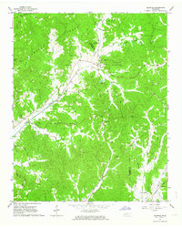
1961 Map of Silerton
USGS Topo · Published 1964About this map
Chickasaw State Park dominates the northern terrain of this 1961 survey, where the border of Hardeman and Chester counties cuts through a landscape of creek bottoms and forested ridges. The Gulf Mobile and Ohio Railroad serves as the primary industrial corridor, connecting the small community of Silerton with surrounding hamlets like Palestine and Woodville. This era shows a well-established network of rural institutions, particularly along the winding courses of Piney Creek and Greasy Creek. Genealogists will find a high density of burial sites and country churches, including Old Concord Cem, Coopers Chapel Cem, and Hickory Grove Ch. Unique infrastructure for the period is visible near the park, such as a Fish Hatchery and a Lookout Tower, reflecting a mix of natural resource management and local transport-driven settlement patterns.
Find a feature on this map
44 named features on this map. Tap any name to fly to it.
Don’t see what you’re looking for? This feature index may not catch every label — zoom into the map to look around manually.
Map Details
Editions of this 1961 Silerton Map
2 editions found
Other maps of this area

1950 · Hebron
USGS Topo · 1:24,000

1950 · Hornsby
USGS Topo · 1:24,000

1951 · Hebron
USGS Topo · 1:24,000

1951 · Hornsby
USGS Topo · 1:24,000

1951 · Rose Creek
USGS Topo · 1:24,000

1956 · Blytheville
USGS Topo · 1:250,000

1959 · Blytheville
USGS Topo · 1:250,000

1961 · Medon
USGS Topo · 1:24,000
1961 · Bolivar East
USGS Topo · 1:24,000
1961 · Henderson
USGS Topo · 1:24,000