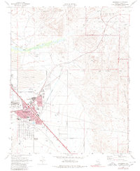
1970 Map of Henderson
USGS Topo · Published 1980About this map
Henderson serves as the industrial and residential heart of this desert landscape, captured just as the city was transitioning through its mid-century expansion. The map details the heavy industrial footprint of the era, dominated by the massive Tailings Ponds and the Three Kids Mine to the northeast. Residential growth is evident in established neighborhoods like Carver Park and newer developments such as Apache Trailer Park, while civic life is anchored by Basic High Sch and Sewell Sch.
Find a feature on this map
59 named features on this map. Tap any name to fly to it.
Don’t see what you’re looking for? This feature index may not catch every label — zoom into the map to look around manually.
Map Details
Editions of this 1970 Henderson Map
4 editions found
Other maps of this area

1886 · Camp Mohave
USGS Topo · 1:250,000

1886 · Saint Thomas
USGS Topo · 1:250,000

1892 · Camp Mohave
USGS Topo · 1:250,000

1893 · Saint Thomas
USGS Topo · 1:250,000

1907 · Las Vegas
USGS Topo · 1:250,000

1908 · Las Vegas
USGS Topo · 1:250,000

1910 · Ivanpah
USGS Topo · 1:250,000

1912 · Ivanpah
USGS Topo · 1:250,000

1926 · Nelson
USGS Topo · 1:96,000

1926 · Boulder Canyon
USGS Topo · 1:96,000